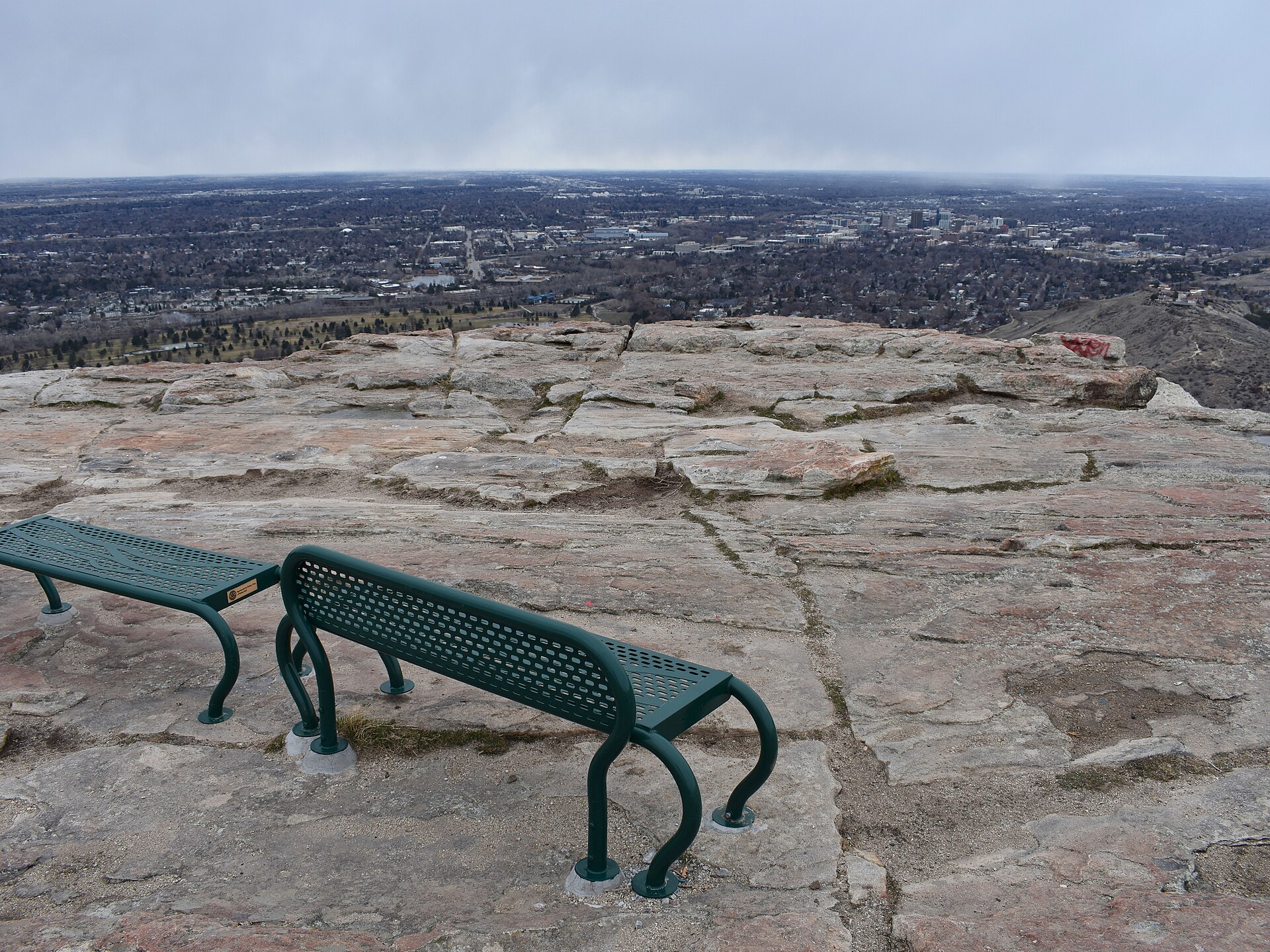
The Boise Bench is the broad, flat terrace of land that sits above and south of the Boise River, separated from the downtown river valley by a distinct rise in elevation. It is called a “bench” because that is the geological term for exactly this kind of landform — a level shelf cut into higher ground by a river, standing above the valley floor like a shelf or step.
What is the Boise Bench, physically?
The Bench is a terrace, not a hill or a neighborhood boundary drawn by planners. It runs roughly parallel to the Boise River, lifted anywhere from around 50 to 200 feet above the river valley depending on location, and it extends south from the edge of that rise toward the flatter Snake River Plain. The drop between the valley floor — where downtown, the river, and the Boise Greenbelt sit — and the top of the Bench is often abrupt enough to see as a single ridge line when driving south from the city center.
Why is it called a “bench”?
In geology and in Western American usage generally, a “bench” describes a level or gently sloping area bounded by a steeper slope on one side and a drop on the other — essentially a step in the landscape, formed as a river or ancient lake cuts down through softer material over long periods and leaves a flatter shelf standing above the new, lower channel. Idaho’s terrain around Boise shows this pattern repeatedly, and Boise’s own Bench is simply the most prominent and most built-upon example of it in the city. The name predates any formal neighborhood boundary; residents and mapmakers were calling the terrace “the Bench” well before it carried house numbers.
How did the Bench get settled and farmed?
For much of the 19th century, the Bench was dry, sagebrush-covered ground unsuited to farming without irrigation, even though the Boise River ran just below it. That changed with large-scale canal building starting in the 1890s and early 1900s, when private companies and later the federal Bureau of Reclamation built systems including the New York Canal to carry water up and across the terrace. The Bureau of Reclamation’s own materials describe this broader effort as the Boise Project, a Reclamation-era irrigation scheme that turned large stretches of southwestern Idaho, including the Bench, into productive farmland.
Once water reached it, the Bench became known for orchards and truck farms in the early 20th century, a period documented in Idaho State Historical Society reference material on the region’s agricultural history. That farmland was gradually subdivided into housing through the 20th century as Boise grew, which is why much of the Bench today reads as an older, grid-platted residential landscape rather than a postwar suburb.

What neighborhoods make up the Bench today?
The city of Boise’s neighborhood association program recognizes several distinct areas across the terrace, including Central Bench, Vista, Depot Bench, Morris Hill, and West Bench, among others. These are administrative and community groupings rather than geological ones, and their boundaries don’t always line up neatly with the edge of the terrace itself — some Bench neighborhoods extend partway down the slope toward the river, and some river-adjacent neighborhoods climb partway up it.
The Bench is distinct from areas covered elsewhere on this site, such as Boise’s North End, which sits on the opposite side of the river and owes its own layout to a different set of 19th- and early 20th-century development patterns, or the East End, which follows the river upstream toward the foothills rather than rising above the valley to the south.
What sits on the Bench now?
The Boise Airport, operated by the city of Boise, sits on the Bench south of downtown — its runways occupy some of the flattest, most open stretches of the terrace, a location that made sense once the area was no longer needed for orchards. Vista Avenue runs as one of the Bench’s principal north–south spines, connecting the airport area back toward downtown and the river.
The Boise Depot is one of the clearest physical demonstrations of the terrace’s height: the depot building was deliberately sited on the edge of the Bench overlooking the city, a placement the city’s own history of the building addresses directly. Readers can find more on the structure itself in the guide to the Boise Depot’s history and architecture, on its grounds in the piece on the Boise Train Depot and Platt Gardens, and on the wider rail network the depot once anchored in the article on what remains of Boise’s railroad history today.
How does the Bench differ from downtown and the river valley?
Downtown Boise, the Basque Block, the Grove Plaza, and the Greenbelt corridor all sit in the lower river valley, below the Bench’s rise. The elevation difference is not dramatic enough to change the climate, but it does change the street pattern and the sightlines: streets on the Bench tend to run in long, uninterrupted grids typical of platted agricultural land, while the valley floor is shaped more directly by the river’s curve and by the historic railroad corridor documented on this site’s neighborhoods archive.
Capitol Boulevard, which connects the Idaho State Capitol to the Boise Depot along a formal axis, effectively links the valley floor to the base of the Bench, and the piece on what Capitol Boulevard connects covers that route in detail.
Is the Bench part of “central Boise” or a separate district?
It functions as its own set of residential districts rather than as an extension of the downtown core, even though parts of it sit close enough to downtown to be considered central. For a broader sense of how Boise’s neighborhoods relate to one another and to the river valley, the Boise guide hub and the neighborhoods category both cover individual districts in more depth, while the living in Boise hub addresses how residential areas like the Bench actually function day to day, from schools to commuting patterns, rather than treating them as sightseeing stops.
Does the name appear on official maps?
Yes, though inconsistently. “Boise Bench” appears in Ada County and city of Boise planning documents, in Idaho State Historical Society material on the area’s agricultural past, and in older U.S. Geological Survey topographic references to the terrace itself, even though no single municipal boundary is drawn around it labeled simply “the Bench.” Readers checking current details on any of the institutions or programs referenced here should confirm specifics directly on the Bureau of Reclamation’s own site, since irrigation infrastructure and land use records are maintained and updated independently of any secondary account.
Why does the distinction matter to a visitor or resident?
For a visitor, the practical effect is mostly about orientation: a map of Boise makes more sense once the Bench is understood as a genuine change in elevation rather than a vague direction called “south of downtown.” For a resident, or anyone considering a move to one of the Bench’s neighborhood associations, it explains a few concrete things — why some Bench streets run on long straight grids inherited from old farm parcels, why irrigation infrastructure still shows up in property records across the area, and why the terrace’s edge, rather than any modern boundary line, is still the fastest way to tell whether you’re standing on the Bench or down in the valley.
Readers planning to explore how the rest of Boise’s geography and neighborhoods fit together can find related coverage across the landmarks and sights archive and the practical planning hub, both of which treat the city’s layout as something to be understood rather than simply toured.
Access Boise is an independent guide written from published, checkable sources. We have not visited the places described here and we do not publish personal recommendations or invented ‘local favourites’ — where something is singled out as notable, we say who says so. Opening times, fares, closures and prices change at short notice, so treat everything here as a starting point and confirm with the museum, operator or venue directly before building a day around it. We give no advice on visas, insurance, health or safety; use your own government’s official guidance for those.
Featured image: Photo by Tamanoeconomico, source, CC BY-SA 4.0
